
ConnectField
Mobile app to improve the reliability of your infrastructure data in the field
Simplify and improve the reliability of field data collection while streamlining consolidation and data sharing processes in the office. Automate quality control, detect anomalies, and secure your geospatial data repository in line with your business rules and standards.
ConnectField is a geolocated mobile app designed for audits, surveys, asset inventories, worksite monitoring, and maintenance operations.
It enables field teams to view, collect, and update data related to infrastructure assets or technical points, even in challenging conditions (on the move, offline, or with input constraints).
A mobile field data collection solution designed for users
ConnectField is a business-oriented solution designed for organizations managing infrastructure networks and assets, where data is at the core of decision-making: ensuring data reliability, capturing observations, qualifying data, documenting assets, and delivering actionable information.
This business-focused approach translates into concrete benefits:
- Fast onboarding with no complex training required
- A field-oriented workflow (data entry, photos, offline mode, dashboards, map visualization, embedded navigation…)
- A proven user experience, validated by field technicians and operators, that accelerates deployment, drives user adoption, and helps organizations better control costs (training, support, configuration, operations)
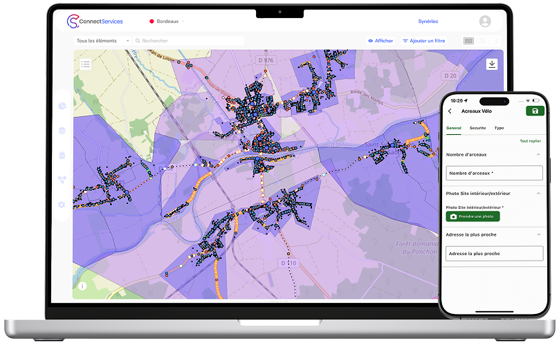
ConnectField + ConnectServices the complete solution for your field data collection
On the Web GIS platform, field operations are planned from the office based on asset types, geographic location, and team skills.
Assigned tasks are then sent directly to the technician’s mobile device, enabling simple and efficient data collection in the field by following predefined workflows.
Once synchronized, the collected data is available in real time on ConnectServices for validation by administrators.
The solution also enables the generation of clear, consolidated reports, making it easier to share information across project stakeholders and support decision-making.
There are many field data collection solutions available, but not all address the same needs and often expose both office and field users to inefficiencies that lead to significant time loss.
Combined with the ConnectServices GIS platform, ConnectField stands out as a leading all-in-one solution that ensures reliable field data collection and saves valuable time in managing audits and field operations.
Field use cases:: what you can achieve with ConnectField
Field audits, inspections and surveys
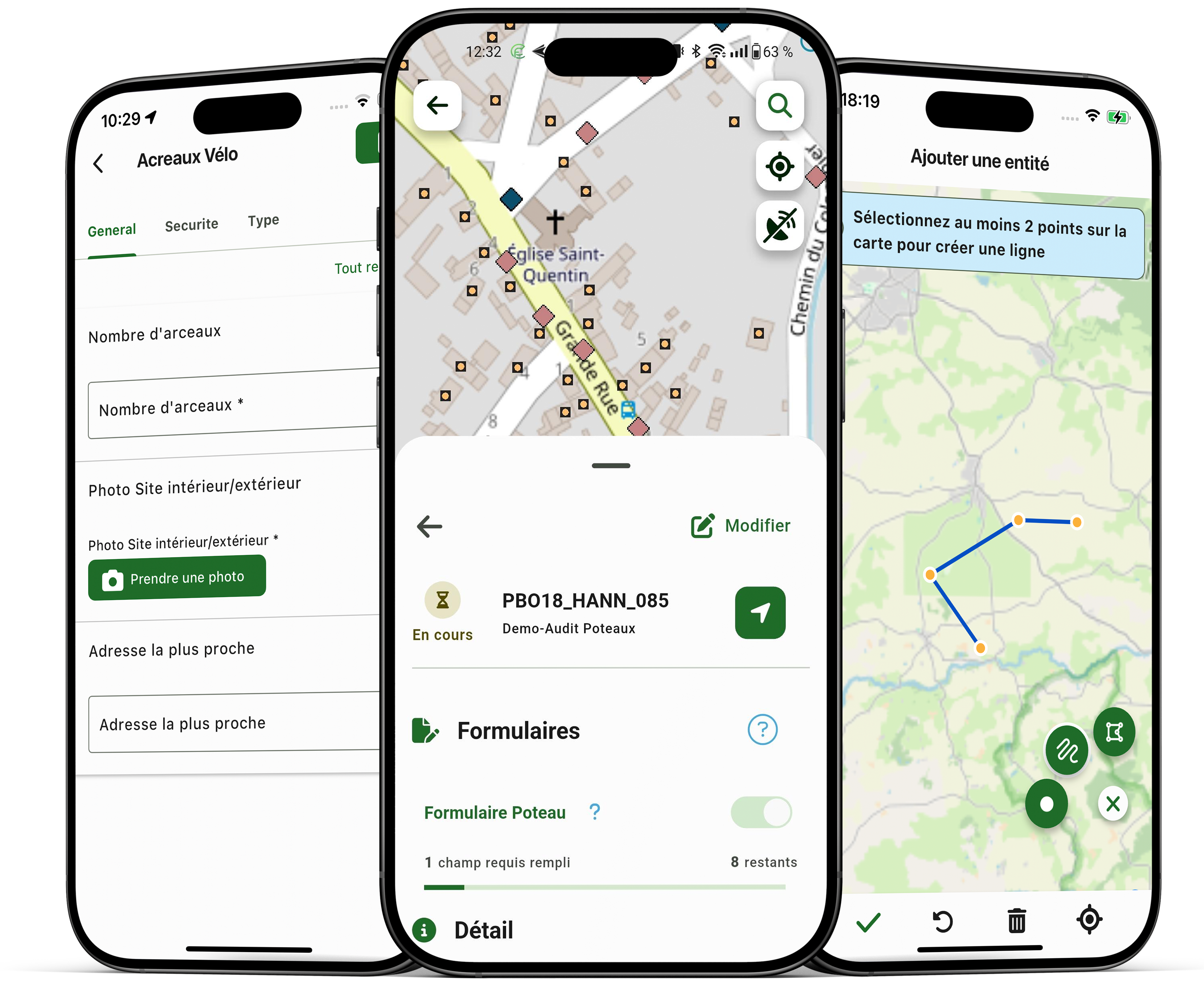
With ConnectField, your teams carry out geolocated and fully documented field audits: observations, data qualification, photos, comments, statuses… The goal is to provide a clear and consistent view of field reality, without duplicate data entry.
Network maintenance and field service management
ConnectField simplifies maintenance operations: locate assets, log incidents, record interventions, qualify issues, and track resolution. Connected to the Web GIS platform, it ensures seamless continuity between field and office.
Asset inventory and network mapping
As infrastructure networks evolve or when existing data lacks accuracy, it may be necessary to create new assets or reposition existing ones. The entity creation feature (points, lines, polygons) enables asset inventory, issue reporting, position correction, and new asset deployment.
Construction site monitoring and issue resolution
With ConnectField, worksite monitoring becomes more efficient: structured observations, photo evidence, status tracking, progress monitoring, and consolidation into a single source of truth.
Note: ConnectServices integrates geospatial data from all types of infrastructure. In the event of a natural disaster, the solution can be shared across all stakeholders involved in network operations (electricity, roads, water, telecom), enabling faster damage assessment and improved coordination of restoration efforts.
Field-ready features designed for operational efficiency

Geolocation: enhancing field operations and data quality
ConnectField is a geolocated mobile app: users can navigate, locate assets, and capture data as close as possible to real field conditions. Geolocation also improves intervention reliability and provides an accurate view of where data is collected.

Offline mode: operate without network coverage
In the field, connectivity is not always guaranteed. Offline mode allows teams to work in low or no network coverage areas and ensures uninterrupted field operations.

Photo evidence: capture and share proof in the field
Capturing photos directly within forms provides objective evidence, simplifies validation, and ensures transparency in communication.

GIS entity creation: map, update and qualify assets and field issues
Entity creation (points, lines, polygons) enables site planning studies, pre-project asset inventories, position adjustments, issue reporting, and inventory completion. Combined with data editing capabilities in ConnectServices, this feature allows you to build your own geospatial data repository -editable, updatable, and shareable.
Geolocation: achieve centimeter-level accuracy

Custom forms for structured and reliable data collection

Built-in navigation: optimize intervention times
