
Use case
Digital Solutions for Telecom and FTTH Networks Audits
From intervention planning to report generation—including field audits—centralize all your fiber network inspection operations (FTTH, FTTO, FTTB) within a single digital platform.
In telecom projects—especially in FTTH deployment and network operations—high-quality field data is essential. Yet, discrepancies between GIS data and real-world conditions are frequent: misaligned infrastructure, incomplete datasets, or outdated information following field interventions.
These inconsistencies directly impact operations, resulting in longer audit times, interpretation errors, and challenges in planning interventions or ensuring compliance of deliverables.
To overcome these challenges, Dotic offers a digital solution that enables field teams to conduct telecom audits in a structured and efficient way using a mobile application connected to the GIS. Field data is instantly integrated into the Web GIS platform, making it immediately available for analysis and operational use.
Limitations of traditional telecom and FTTH field audits
Telecom audits still rely on outdated and inefficient methods that are not suited to modern FTTH network requirements:
- paper-based or spreadsheet-based field data collection
- manual data entry and duplication
- fragmented tools leading to data inconsistencies
- lack of integration with GIS platforms
- limited accuracy in asset geolocation
In FTTH environments, these challenges are amplified by:
- complex infrastructure (underground chambers, connection points, cables)
- high data volumes
- multiple contractors and stakeholders
- strong compliance and quality requirements
As a result, organizations face unreliable data, limited usability, long processing times, and poor traceability of audit operations.
Digitize telecom audits with a connected GIS solution
Digitizing field audits transforms the way organizations collect, validate, and leverage data across telecom operations.
With Dotic, field teams use ConnectField, an intuitive mobile application, to perform audits directly on site, fully connected to the ConnectServices Web GIS platform for real-time data integration and management.
ConnectField: the next-generation mobile app for field audits
ConnectField is a mobile field audit application that enables teams to perform audits directly on site from their smartphones, fully connected to GIS data.
It allows users to:
- access and visualize existing geospatial data
- accurately locate infrastructure assets to inspect
- collect structured data using customizable digital forms
- capture geolocated photos and field observations
- update and synchronize existing datasets
The application adapts to operational workflows and guides users step by step through field inspections.

Direct integration with the Web GIS platform: ConnectServices
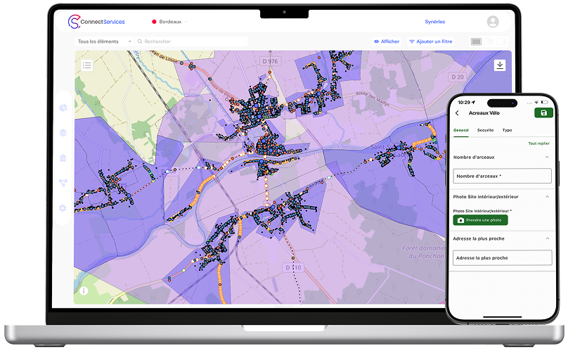
The platform provides end-to-end capabilities to:
- select and manage assets to be audited
- assign field technicians and tasks
- configure forms based on asset types
- visualize and track completed audits
- centralize and manage field data
- validate data quality and consistency
- access and analyze data in real time
- generate customizable audit reports
Seamless integration between the mobile field app and ConnectServices ensures high-quality, reliable data while eliminating manual data entry errors.
Use case: auditing an FTTH network
Before implementing a digital audit solution:
- manual extraction of GIS data
- reliance on static maps
- inconsistent field data collection
- manual data entry and duplication
- incomplete updates of GIS datasets
With Dotic’s digital audit solution:
- Audit datasets are prepared and managed in the ConnectServices Web GIS platform.
- Field teams access all project data in real time on their smartphones via the ConnectField mobile app.
- Audits are carried out directly on site using structured digital forms, including:
- inspection of telecom chambers
- verification of connection points and distribution equipment
- validation of cable routing
- updating infrastructure attributes
- …
- Field data is automatically synchronized with the platform.
- Teams analyze, validate, and use the results in the Web GIS platform for operational decision-making.

Key benefits of our telecom and FttH network field audit solution
A structured workflow: from field audits to office GIS tools
Audit preparation
- selection of inspection areas
- structuring and standardization of datasets
- configuration and assignment of operational forms
Field data collection with ConnectField
- map-based visualization of assets to be inspected
- guided data entry
- precise geolocation
- offline capability
Data synchronization
- automatic database updates
- elimination of manual data entry
Data analysis in ConnectServices
- visualization of audit results
- quality control of collected data
- operational management
- report generation
Want to improve your telecom data quality and structure your field audits?
Discover how ConnectField and ConnectServices connect field teams to GIS to improve efficiency, save time, and ensure reliable network data.