
Use Cases
Monitoring and management of infrastructure incidents and FTTH connection failures
As part of Dotic’s commitment to simplifying access to geospatial data and infrastructure management processes, the ConnectServices GIS platform includes advanced tracking capabilities for infrastructure incidents and FTTH connection failures.
The solution helps network owners and infrastructure managers improve collaboration with contractors, operators, and field teams while ensuring better operational visibility and network quality
In fiber network operations, network owners and infrastructure managers continuously receive operational datasets from operators, subcontractors, and maintenance providers.
To monitor infrastructure incidents and FTTH connection failures, these datasets typically include information such as connection failures, network damages, and customer service performance indicators.
However, this data is often shared through complex files and disconnected reporting systems, making autonomous analysis and operational monitoring difficult without dedicated GIS tools.
As a result, infrastructure managers may struggle to visualize incidents, understand operational issues, track service restoration timelines, and ensure long-term network reliability and maintenance.
ConnectServices addresses these challenges by providing a collaborative and user-friendly GIS platform that centralizes and visualizes operational data in real time. Infrastructure managers gain access to advanced monitoring tools, detailed indicators, and analytics related to network damages caused by weather events, road incidents, or operational failures, as well as the root causes of FTTH connection failures.
Combined with the ConnectField mobile GIS solution, field teams can perform on-site visual inspections to validate operational data directly in the field, improving data reliability, operational transparency, and compliance management.
Cross-reference operational data with your FTTH network infrastructure
The new module enables infrastructure managers and network owners to correlate operational data provided by operators and contractors with their fiber network asset data.
Incident and operational datasets provided by operators are correlated across different data models and operational systems, combining the digital representation of the fiber network with Dotic’s dedicated operational data framework.
This correlation makes it possible to associate each operational event with real network assets and infrastructure components, providing clear and actionable indicators related to issues affecting the fiber network.
Quickly identify areas experiencing FTTH network operational issues
This geospatial view helps highlight sensitive areas and supports the prioritization of corrective actions and operational decisions.
The GIS platform allows users to visualize and analyze:
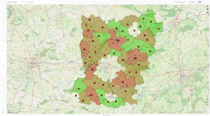
Example of an FTTH network incident heat map
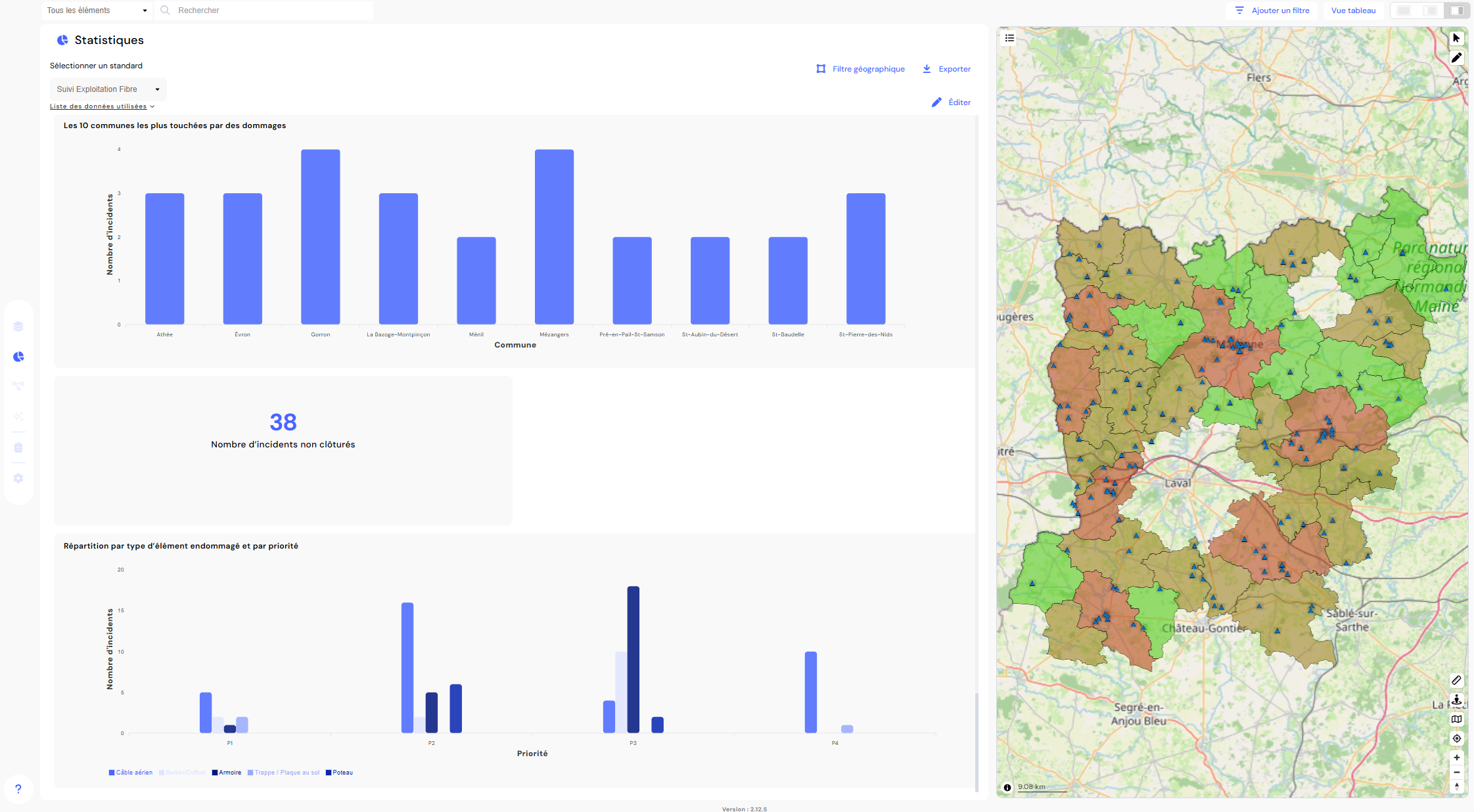
Analyze the service quality of your FTTH network
The solution also provides access to operational KPIs and network performance analytics, including:
- the number of FTTH connection failures
- the number of network damages categorized by repair or restoration priority
- customer service incidents over a selected period
- service restoration times
- the distribution of incidents across network areas
- …
These indicators help infrastructure managers and network owners better understand operational challenges across their fiber network, identify recurring problem areas, and improve operational decision-making through historical data analysis.
Generate operational reports for FTTH network monitoring
To simplify operational management and collaboration with operators, contractors, and maintenance providers, the solution enables the generation of detailed analytical reports.
These reports support transparent collaboration and contribute not only to infrastructure resilience, but also to long-term operational monitoring and service performance management throughout the lifecycle of the network.
Reports can be generated at different geographic or network levels, such as central offices, distribution nodes, or connection points.

Example of an operational report with geolocated photo evidence captured in the ConnectField mobile application
Leverage operational data to improve network management and decision-making
By integrating operational and incident data into the ConnectServices GIS platform, infrastructure managers gain greater visibility and control over their fiber network assets.
They can:
- visualize infrastructure incidents across the network in real time
- identify areas impacted by recurring FTTH connection issues
- track network service quality KPIs and operational indicators
- improve transparency and collaboration with operators, subcontractors, and maintenance providers
Operational data is transformed into actionable insights that support network management, operational decision-making, and long-term infrastructure performance.
Unlike generic GIS platforms, this Dotic service is specifically designed for fiber network operations and enables infrastructure managers to instantly transform operational data into actionable geospatial insights—without technical complexity or advanced GIS expertise.